Featured Posts

- Index of Psychological Studies of Presidents and Other Leaders Conducted at the Unit for the Study of Personality in Politics
- The Personality Profile of U.S. Supreme Court Associate Justice Brett Kavanaugh
- The Leadership Style of North Korean Leader Kim Jong-un
- North Korea Threat Assessment: The Psychological Profile of Kim Jong-un
- Russia Threat Assessment: Psychological Profile of Vladimir Putin
- The Personality Profile of 2016 Republican Presidential Candidate Donald Trump
- Donald Trump's Narcissism Is Not the Main Issue
- New Website on the Psychology of Politics
- Unit for the Study of Personality in Politics --- 'Media Tipsheet'
categories

- Afghanistan (228)
- Al Gore (2)
- Amy Klobuchar (4)
- Ayman al-Zawahiri (7)
- Barack Obama (60)
- Ben Carson (2)
- Bernie Sanders (7)
- Beto O'Rourke (3)
- Bill Clinton (4)
- Bob Dole (2)
- Campaign log (109)
- Chris Christie (2)
- Chuck Hagel (7)
- Criminal profiles (8)
- Dick Cheney (11)
- Domestic resistance movements (21)
- Donald Trump (31)
- Economy (33)
- Elizabeth Warren (4)
- Environment (24)
- George H. W. Bush (1)
- George W. Bush (21)
- Hillary Clinton (9)
- Immigration (39)
- Iran (43)
- Iraq (258)
- Jeb Bush (3)
- Joe Biden (13)
- John Edwards (2)
- John Kasich (2)
- John Kerry (1)
- John McCain (7)
- Kamala Harris (5)
- Kim Jong-il (3)
- Kim Jong-un (11)
- Law enforcement (25)
- Libya (18)
- Mahmoud Ahmadinejad (6)
- Marco Rubio (2)
- Michael Bloomberg (1)
- Michele Bachmann (173)
- Mike Pence (3)
- Military casualties (234)
- Missing person cases (37)
- Mitt Romney (13)
- Muqtada al-Sadr (10)
- Muslim Brotherhood (6)
- National security (16)
- Nelson Mandela (4)
- News (5)
- North Korea (36)
- Osama bin Laden (19)
- Pakistan (49)
- Personal log (25)
- Pete Buttigieg (4)
- Presidential candidates (19)
- Religious persecution (11)
- Rick Perry (3)
- Rick Santorum (2)
- Robert Mugabe (2)
- Rudy Giuliani (4)
- Russia (7)
- Sarah Palin (7)
- Scott Walker (2)
- Somalia (20)
- Supreme Court (4)
- Syria (5)
- Ted Cruz (4)
- Terrorism (65)
- Tim Pawlenty (8)
- Tom Horner (14)
- Tributes (40)
- Uncategorized (50)
- Vladimir Putin (4)
- Xi Jinping (2)
- Yemen (24)
Links

archives

- November 2021
- January 2021
- November 2020
- October 2020
- September 2020
- August 2020
- July 2020
- April 2020
- March 2020
- February 2020
- January 2020
- December 2019
- October 2019
- July 2019
- May 2019
- April 2019
- March 2019
- February 2019
- January 2019
- December 2018
- September 2018
- August 2018
- July 2018
- June 2018
- April 2018
- March 2018
- February 2018
- January 2018
- August 2017
- July 2017
- June 2017
- May 2017
- April 2017
- February 2017
- January 2017
- December 2016
- November 2016
- October 2016
- September 2016
- August 2016
- July 2016
- June 2016
- May 2016
- April 2016
- March 2016
- February 2016
- January 2016
- December 2015
- November 2015
- October 2015
- September 2015
- August 2015
- July 2015
- June 2015
- May 2015
- April 2015
- March 2015
- February 2015
- January 2015
- December 2014
- November 2014
- October 2014
- September 2014
- August 2014
- July 2014
- June 2014
- May 2014
- April 2014
- March 2014
- February 2014
- January 2014
- December 2013
- November 2013
- October 2013
- September 2013
- August 2013
- July 2013
- June 2013
- May 2013
- April 2013
- March 2013
- February 2013
- January 2013
- December 2012
- November 2012
- October 2012
- September 2012
- August 2012
- July 2012
- June 2012
- May 2012
- April 2012
- March 2012
- February 2012
- January 2012
- December 2011
- November 2011
- October 2011
- September 2011
- August 2011
- July 2011
- June 2011
- May 2011
- April 2011
- March 2011
- February 2011
- January 2011
- December 2010
- November 2010
- October 2010
- September 2010
- August 2010
- July 2010
- June 2010
- May 2010
- April 2010
- March 2010
- February 2010
- January 2010
- December 2009
- November 2009
- October 2009
- September 2009
- August 2009
- July 2009
- June 2009
- May 2009
- April 2009
- March 2009
- February 2009
- January 2009
- December 2008
- November 2008
- October 2008
- September 2008
- August 2008
- July 2008
meta

Late Friday afternoon, July 1, a line of severe thunderstorms hit St. Cloud, Minn., and surrounding communities with heavy rain, large hail, and near-hurricane-force downburst winds of 65 to 70 miles an hour toppling hundreds of trees, some of which landed on buildings and vehicles.
The National Weather Service reported that a weak tornado (EF0) briefly touched down on the west side of the St. Cloud metro at about 6:25 p.m.  The 30-yard-wide twister touched down just north of the I-94 and Minnesota Highway 23 junction and moved northeast for about 2.3 miles before dissipating in Waite Park, about a mile and a half west of the intersection Highways 23 and 15.
Photo chronicle
Click on photos for larger image
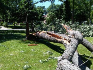
Downed tree in Hester Park, adjacent to St. Cloud Hospital
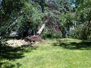
Tree on home near St. Cloud Hospital (side view from west)
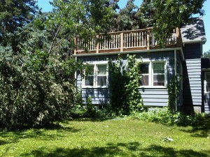
Tree on home near St. Cloud Hospital (front view from south)
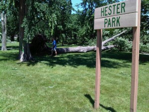
St. Cloud Mayor Dave Kleis surveys storm damage in Hester Park
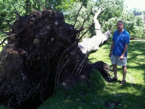
St. Cloud Mayor Dave Kleis inspects storm damage in Hester Park
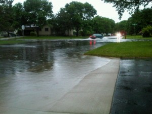
Street flooding in Sartell, north of St. Cloud
Click on photos for larger image
—————————————————————————————
Update: National Weather Service storm report
Tornado in Waite Park and a Downburst in St. Cloud
The National Weather Service assessed the damage caused by the storms Friday evening, July 1, [2011] in eastern Stearns County, including the cities of Waite Park and St. Cloud.
Tornado location: The tornado touched down just northeast of the intersection of Interstate 94 and Highway 23. It moved northeast and dissipated in Waite Park, about 1.5 mile west of the intersection of Highways 15 and 23.
Path length: 2.3 miles.
Maximum wind speed: About 65 mph.
Maximum width: Approximately 30 yards.
Tornado damage: Dozens of trees were broken or toppled as it moved northeast. It did not appear that the tornado was continuously on the ground but there were five distinct locations of convergent damage along its path.
Timing: It appears to have touched down at about 6:23 pm and dissipated at about 6:26 pm. This is estimated based on radar.
Downburst location: Most damage was north of downtown St. Cloud and was spread over several square miles. It extended into Benton County.
Downburst maximum wind speed: 65 to 70 mph.
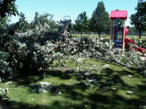
Downburst damage: Hundreds of trees were toppled, broken, or pushed over. Many trees landed on houses, sheds, and vehicles. The downburst damage was far more widespread and significant than the tornado damage.
Downburst notes: It is likely that the downburst lasted for many minutes in some areas.
Other damage: There was sporadic tree damage from Rockville to St Cloud. This was much less concentrated than the Waite Park tornado damage or the St. Cloud downburst damage.
The National Weather Service would like to thank Skywarn storm spotters, law enforcement, and media who provided or relayed critical reports to the National Weather Service in real time. A special thank you is given to Stearns County Emergency Management for assisting in the damage survey.
————————————————
Related reports on this site
Everett Balko observes damage from strong storms near Little Rock Lake. (Photo credit: Dave Schwarz / St. Cloud Times)
Weather Conditions in Minnesota (May 24, 2011)
North Minneapolis Tornado (May 22, 2011)
Severe Storm Hits Sartell and Rice, Minnesota (Aug. 14, 2010)
————————————————————————————————
FROM THE ARCHIVES: One Year Ago — July 3, 2010
Wetterling Suspect Dan Rassier


Jared S., Jacob Wetterling, and Joshua Guimond
One year ago today, I reported that Stearns County Sheriff John Sanner described music teacher Dan Rassier as a “person of interest” in the abduction of Jacob Wetterling at the end of the Rassier driveway on Oct. 22, 1989. In that regard, I discussed aspects of criminal motive and the likely offender profile, noting the need for a linkage analysis involving the unsolved kidnapping and sexual assault of Jared S. in nearby Cold Spring and the unexplained disappearance of Joshua Guimond from a college campus in close proximity to the two abduction sites.
—————————————————————————————————
FROM THE ARCHIVES: Two Years Ago — July 3, 2009
Sarah Palin Personality Profile
Two years ago today, on the occasion of Alaska Gov. Sarah Palin’s sudden resignation from office on July 3, 2009, I featured my research on Palin’s personal psychology, conducted at the Unit for the Study of Personality in Politics.
Leave a Reply
You must be logged in to post a comment.



July 4th, 2011 at 10:25 am
[…] Severe Storm Hits St. Cloud, Minnesota (July 3, 2011) […]
May 23rd, 2012 at 12:25 am
[…] Severe Storm Hits St. Cloud, Minnesota (July 3, 2011) […]